Return to Map Specimen Database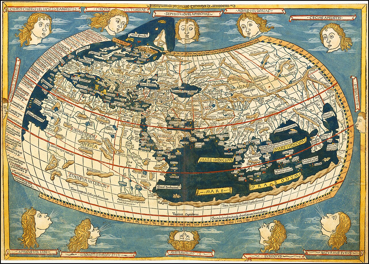
Era: Ancient & Medieval·Cartographer: Claudius Ptolemy (1482 Ulm Engraving by Lienhart Holle)·Year: 150·US Government Public Domain
Ptolemy’s Geographia World Map
"The foundational map establishing coordinate latitude, longitude, and mathematical spherical projection"
Published in Alexandria c. 150 CE and rediscovered in Renaissance Europe, Ptolemy’s map cataloged over 8,000 localities with mathematical latitude and longitude coordinates, depicting the known ecumene from Britain to China.
Interactive Specimen Pan & ZoomAccession: G3200 1482 .P8
Orientation: North-Up
410 × 560 mm
Claudius Ptolemy (1482 Ulm Engraving by Lienhart Holle)·150·Library of Congress, Washington D.C.
ZOOM: 100%Repository Archive
Notable Cartographic Signatures
- First systematic latitude and longitude coordinate graticule
- Enclosed Indian Ocean depicted as a landlocked inland lake (Terra Incognita)
- 12 classical wind heads blowing into the edges
The Rhetorical & Ideological Argument
"Space is fundamentally an objective mathematical continuum that can be calculated, indexed by numbers, and framed within curved parallels."
Explicit Features
- First systematic latitude and longitude coordinate graticule
- Enclosed Indian Ocean depicted as a landlocked inland lake (Terra Incognita)
- 12 classical wind heads blowing into the edges
Intentional Omissions
- The Americas and Pacific Ocean (unknown to Greco-Roman geographers)
Physical Specimen & Geodesy
Projection:
Ptolemy's First Modified Conic Projection
Orientation Axis:
North-Up
Physical Medium:
Hand-colored woodcut on laid paper
Original Physical Dimensions:
410 × 560 mm
Custodial Repository:
Library of Congress, Washington D.C.
Accession: G3200 1482 .P8
Interdisciplinary Context & Connections
LunologiumCALCULATED_BY
Astronomical Graticule Positioning
MorphologiumDEVELOPS
Conic Projection Coordinate Manifolds
Academic Provenance: Ptolemy, C. (1482)